AbstractThe innovator plays an important role in the diffusion process: that of launching the new idea in the system by importing the innovation from outside the system boundaries.
Everett M. Rogers (1931–2004)
Communication theorist and sociologist
In Diffusion of Innovations (2003)
While traditional approaches to innovation diffusion often assume that innovations come from outside a local system, transdisciplinary co-production offers an alternative paradigm in which local stakeholders are engaged as co-producers of innovations. The use of digital online tools for agriculture, conservation, and citizen science is an area of expanding opportunities, but landholders are often dependent on tools developed outside their local communities. This article looks at the potential for transdisciplinary co-production to be used as a framework for more participatory development of digital online land management tools, with a case study from the Central Tablelands of New South Wales, Australia. This research has implications beyond rural land management to other industries and contexts where reflexive and integrative strategies are needed to overcome barriers to stakeholder participation and engagement with new technologies.
Introduction
As demonstrated by the quotation that opens this article, innovation diffusion is often conceived of as a process of importing innovations into a system from outside, with local stakeholders then deciding whether to adopt them. However, such an approach can result in the knowledge, values, and needs of certain stakeholders being excluded from the innovation process. This can be particularly problematic for the development and application of digital technologies in rural and remote areas, where factors such as Internet access, technological proficiency, education, age, and cultural background can impact on the capacity of local community members to adopt and utilize technological innovations (Carver et al., 2009; Cinnamon & Schuurman, 2013; Haklay, 2013; Radil & Anderson, 2018). Transdisciplinary approaches offer an alternative to the notion of “importing” innovations by engaging multiple stakeholders and knowledge types in the innovation process, including diverse types of disciplinary and expert knowledge as well as practical and local knowledge (Lang et al., 2012). Transdisciplinary approaches are relevant not only to rural land management but also to a diverse range of contexts including urban planning (Polk, 2015), waste management (Smith, 2017), health (Darrell, 2016), and higher education (Petra & Christian, 2017).
Digital online tools for rural land management are a growing area of interest for academic research and industry development. This trend encompasses both agricultural production and conservation-based management and may be framed as digital agriculture (Trindall et al., 2018), spatial decision support systems (Ramsey, 2009), participatory geographic information systems (Radil & Anderson, 2018), or citizen science (Newman et al., 2017). Advances in geospatial data and tools can facilitate greater collaboration by enabling groups to communicate better, divide up tasks, share data, and integrate different functions such as mapping and communication (Palomino et al., 2017). Such tools also have the potential to bridge the gap between the property scale at which landholders commonly make decisions and the broader scales at which cross-property challenges need to be managed, including total grazing management, weeds, and fire (Wyborn & Bixler, 2013).
To understand the innovation process around digital online land management tools, a rich history of rural landholder research can be drawn upon. Everett M. Rogers, whose quotation opens this article, developed his innovation diffusion model after observing the adoption of agricultural innovations among Iowa corn farmers and was influenced by other researchers at Iowa State University (e.g., Ryan & Gross, 1943). His seminal 1962 book Diffusion of Innovations has been influential on the development of broader innovation theory, including his generalized diffusion model, which classifies adopters along a spectrum from innovators to laggards (Figure 1).

Figure 1. Generalized model of adoption over time divided into Rogers’ five adopter categories (redrawn from Rogers, 2003)
Rogers ‘ central argument is that innovation diffusion is a general process that follows similar patterns across diverse contexts ranging from agriculture to medicine to information technology (Rogers, 2003). However, this model has also been subject to criticism, particularly in relation to rural landholders. Pannell and co-authors (2011) argue that it implies “innovativeness” is a characteristic people apply equally to all innovations, while Vanclay (2004) argues that “agriculture has too long been thought of as a technical issue involving the application of science, and the transference of the outputs of that science via a top-down process of technology transfer” (Vanclay, 2004).
In this article, we consider transdisciplinary innovation strategies that are participatory and collaborative rather than “top-down” and apply these to an Australian case study involving the development of a digital online land management tool. Specifically, we apply the framework for “transdisciplinary co-production” developed at Mistra Urban Futures in Sweden (Polk, 2015). In doing so, we seek to demonstrate the versatility of this framework by applying it outside of the urban context in which it was originally developed and on the other side of the world.
Transdisciplinary Co-Production
Transdisciplinarity has been defined in different ways over time (Scholz & Steiner, 2015a), but a central feature of many definitions is the need for participatory engagement with a range of stakeholders. Smith (2017) highlights the influence of participation and deliberative democracy on the development of transdisciplinarity from the 1970s onwards. Similarly, Polk, and Knutsson (2008) emphasize the importance of participatory approaches to transdisciplinary knowledge production in order to incorporate contextualized knowledge, transgress disciplinary boundaries, and subsume “a variety of different non-academic stakeholders, organizations and sites”. Scholz and Steiner (2015b) present a vision of transdisciplinarity that cuts across disciplinary boundaries, involves multi-stakeholder discourse, includes a process of mutual learning, and focuses on practical real-world challenges.
The framework for “transdisciplinary co-production” evaluated in this article was developed at Mistra Urban Futures in Sweden and described by Polk (2015). The framework includes five focal areas: inclusion, collaboration, integration, usability, and reflexivity (Table 1).
Table 1. The five focal areas of Polk’s Transdisciplinary Co-Production Framework (Adapted from Polk, 2015)
|
Focal Area |
Definition from Polk (2015) |
|
1. Inclusion
|
Different groups of stakeholders from both practice and research are entitled to the entire knowledge production process. |
|
2. Collaboration |
The processes and methods for participating as well as the quality and degree of the participation result in in-depth contributions from both practice and research. |
|
3. Integration |
The assimilation, combination and/or synthesis of both practice-based and scientific perspectives, values, knowledge and expertise adequately capture the problem complexity and issues being addressed. |
|
4. Usability |
Assessment and reflection upon the social robustness and transformative capacity of outputs and outcomes occur throughout the research process. |
|
5. Reflexivity |
The project approach includes on-going scrutiny of the choices that are made when identifying and integrating diverse values, priorities, worldviews, expertise and knowledge from both practice and science in the research process. |
While Polk (2015) considers transdisciplinary co-production in relation to urban planning, a precedent has previously been set for the application of the term “transdisciplinary co-production” to rural settings, with Aeberhard and Rist (2009) applying it to the co-production of knowledge on organic farming in Switzerland. The co-production concept also has some overlaps with the concept of “co-management” in natural resource management, which also involves bringing together multiple knowledge types in a process of social learning and adaptation (Berkes, 2009). Unlike Polk (2015), Aeberhard and Rist (2009) did not apply a specific framework for transdisciplinary co-production in their study, but their use of the term demonstrates its versatility in terms of both context and product. In the case of Aeberhard and Rist (2009), the product was knowledge about organic agriculture. For Polk (2015), the products were visions of urban planning. For our case study, the product is a digital online tool that can be used to collaborate on managing land and natural resources.
Our case study project in the Central Tablelands of New South Wales (NSW), Australia, was not initially designed using Polk’s framework and the research team initially chose to frame it as an “interdisciplinary” rather than transdisciplinary project. Scholz and Steiner (2015b) define interdisciplinarity as “the merging of concepts and knowledge from different disciplines”, which does not necessarily incorporate the focus on multi-stakeholder discourse and real-world practice that they view as integral to transdisciplinarity. Our case study clearly meets Scholz and Steiner’s definition of interdisciplinarity, with our research team having expertise in agriculture, geospatial science, environmental management, policy studies and human geography. However, a key question considered in this article is whether the case study also qualifies as transdisciplinary. This question has relevance not only for rural land use projects but for any project that aims to develop digital technology in a manner that is collaborative, participatory and does not easily fit within disciplinary boundaries.
The Central Tablelands Case Study
The two case study areas (labelled as NE and SW in Figure 2) are located in the NSW Central Tablelands region, which lies between the Sydney metropolitan area and the NSW western slopes and plains. The dominant land use is sheep and cattle grazing (NSW Government, 2007), but there has also been an influx of so-called “rural lifestylers” who are not dependent on the land for their income (Central West Independent Review Panel, 2007). The Landcare movement, which brings together conservation and production objectives (Curtis et al., 2014) is represented in the region by many small local groups and some larger umbrella groups such as Watershed Landcare (covering 9000 km2 around Mudgee).
The project, undertaken between January 2016 and January 2018, aimed to assess landholder interest in using online tools to collaborate on land and natural resource management. It was funded by the NSW Environmental Trust and involved three universities (The University of Sydney, The University of New South Wales, and The University of Technology Sydney), as well as Landcare NSW Inc. (the peak body for Landcare groups in NSW) and the Central Tablelands Local Land Services (a NSW Government agency). The research team brought together a range of disciplinary expertise, as well as practical experience in commercial agriculture, conservation, and community engagement.
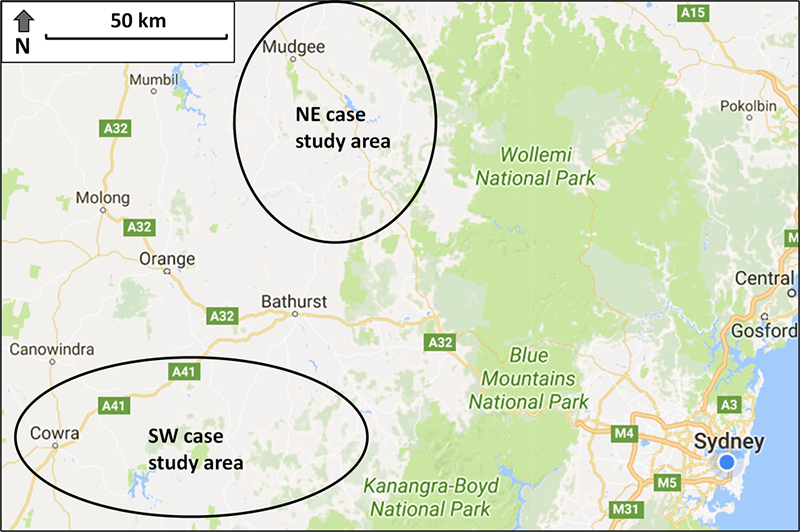
Figure 2. Location of the North-East (NE) and South-West (SW) case study areas in the NSW Central Tablelands (Map data: Google)
Prior to the start of the project, a range of existing online collaboration tools were accessible in the case study areas, including global platforms for spatial analysis (e.g., Google Earth, ArcGIS Online, QGIS Cloud) and social media (e.g., Facebook, Twitter, Instagram). In addition to these global tools, a range of national or regional-scale tools are also applicable to the Central Tablelands region, including a directory of active environmental groups on the NSW Landcare Gateway, spatial data via the NSW Spatial Information Exchange, and Atlas of Living Australia, and citizen science platforms such as FeralScan for reporting feral animal sightings.
The diversity of available tools in the case study area reflects a global trend towards tools that are free, open source, inter-operable, and able to be adapted by user communities (Palomino et al., 2017). However, none of the available collaboration tools were co-produced by or with local stakeholders and the extent to which they may be able to adapt such tools to meet their local needs depends on factors such as Internet access, technological proficiency, education, and institutional support, which can pose particular challenges in rural and remote areas (Cinnamon & Schuurman, 2013; Haklay, 2013).
The case study research followed a participatory approach, with focus groups used to scope key issues and stakeholders, a participatory rural appraisal (PRA) exercise undertaken in each case study area, a questionnaire used to inform the design of an online tool, a series of adaptations made to the NSW Landcare Gateway, and follow-up workshops held to evaluate the new features. Participatory rural appraisal is an approach that treats rural people as co-producers of knowledge (Chambers, 1994). The case study methodology, following Campbell (2001) and Narayanasamy (2009), involved interview teams made up of researchers and local stakeholders spreading out across each case study area to interview and survey landholders over a period of 2–3 days, followed by a concluding workshop to synthesize key findings.
The semi-structured interviews covered land management practices, history of collaboration, interest in further collaboration, and use of online collaboration tools. At the end of each interview, interviewees were asked to complete a written survey covering their level of Internet access and usage, the functions they would most value in a new collaboration tool, requirements of a “user-friendly” tool, the types of data they would be willing to share, and their willingness to pay a fee to access an online tool. For full details of the survey methodology and results, see Baumber and co-authors (2018).
In total, 26 landholders were interviewed in the NE case study area and 29 in the SW area. The NE area had a higher proportion of small-to-medium landholders (n=17/26 interviewees), with more than half identifying as rural lifestylers with an urban background. In contrast, participants in the SW study area were predominantly medium-to-large commercial landholders (n=19/29 interviewees), with most interviewees coming from inter-generational farming families producing sheep (for meat and wool) and beef. The NE area had a more diverse mix of land use activities, including sheep for wool or meat, beef, wine, alpacas, pigs, and land managed for conservation. Interviewees were not asked their age and there was no obvious difference between the two areas in this regard.
The issues for which collaboration was practiced or desired were similar in each area, including weeds and pest animals, ecological restoration, production practices, and tourism. Key results emerging from the survey and interviews included the poor quality of Internet access experienced by many landholders (especially in the SW area), a desire to selectively share some data among a local group rather than with the general public, and an interest in sharing data in a variety of formats such as map-based data, photos, news, events, and monitoring results. Data security was a key concern, and there was a strong interest in mobile device compatibility and simple menu options to make any tool user-friendly. The interest in sharing a wide variety of data formats highlighted the importance of not defining any new tool in narrow terms such as a “mapping” or “citizen science” tool, as well as ensuring that it could be adapted in future to meet diverse and emerging landholder objectives.
The survey results were used to design a series of modifications for the NSW Landcare Gateway. This was selected as the most appropriate platform to trial new features based on the case study results for the following reasons:
- It was operated by a key project partner (Landcare NSW) who was seeking to add new functions.
- It was free for local landholder groups to use.
- Landcare NSW had the resources to keep it operating after the end of the project when funding had ceased.
- It already had much of the critical functionality identified from the social research, including dedicated spaces for local groups and the ability to handle a variety of data sources (map-based data, photos, news/events, and monitoring results).
A series of modifications were made to the NSW Landcare Gateway between March and August 2017, when trials were launched in each of the two case study regions. Figure 3 shows some of these new features, including social media feeds (left-hand side), links (top right), mapping features (sample point features and polygons displayed), and the ability to export data from the maps (“Download group KML” link at bottom right). Additional mapping functionality was added to allow users to add detailed information to each point or polygon, including text descriptions, photos, and data files for download. New sharing permissions were added so that users could choose whether data was visible to themselves only, to other group members, or to the general public. Figure 3 shows the public view for the Glideways Group page; signed-in group members would see additional features on the map. A number of back-end changes were required to make this possible, including streamlined sign-up and login processes and new editing permissions, as only group administrators previously had access rights to upload data and change display settings.
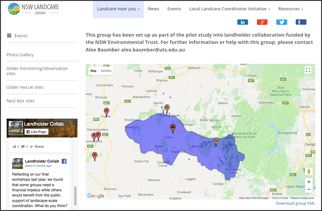
Figure 3. Screenshot showing the incorporation of text, mapping, and social media on the revised NSW Landcare Gateway
In order to trial the changes, one collaborative activity was identified for each case study area based on consultation with participants in the rural appraisal and other local stakeholders. The monitoring of spiders as an indicator of ecosystem health was selected for the NE trial, whereas in the SW area, marsupial gliders were selected as the focus of the trial (e.g., recording observations and nest box sites). Local workshops were held in August 2018 to enable landholders to learn about the new Gateway features and sign up to the trials, with 12 landholders signing up to the NE trial and 11 to the SW trial.
Further workshops were held in December 2018 to evaluate the trials’ progress in each area, and feedback was also sought from individual users of the tool. Trial results to date indicate that some participants value having a space to store data and to share it with neighbours or other stakeholders such as funding bodies. However, a range of challenges has also been identified. Some issues have since been resolved, such as an inability to differentiate between different data types on maps (resolved through additional icons) and an inability to export mapping data for use in other platforms (resolved through added KML and CSV export functions). Other issues remain unresolved, such as a desire for even simpler menus with fewer clicks needed to reach each page, issues around loading speeds in areas with poor Internet access, and difficulties importing data layers of certain formats.
The current status of the project is that the project team continues to work with participating landholders to customize and evaluate the Gateway modifications. Further funding has been sought to implement additional modifications and to extend trials to additional collaborative practices, including revegetation and collaborative management of total grazing pressure.
Evaluation of Project Against the Transdisciplinary Co-Production Framework
The project is evaluated below against each of the five focal areas described by Polk (2015): inclusion, collaboration, integration, usability and reflexivity.
1. Inclusion
The framework requires that “different groups of stakeholders from both practice and research are entitled to the entire knowledge production process” (Polk, 2015).
The project included several different groups of stakeholders involved in land management, including commercial farmers, non-commercial “lifestylers”, government agencies, and local conservation groups. In addition, Central Tablelands Local Land Services, Landcare NSW, and key local groups were also involved in the design of the research alongside the university-based researchers.
Inclusion could be further enhanced through greater consideration of other stakeholder types. Absentee landholders (e.g., those living in cities and visiting properties on weekends) emerged as a group that was difficult to reach via the initial social research design. Agribusinesses and producer groups could also have been included to a greater degree. Other groups that were included, but only to a limited extent, were protected area managers and indigenous groups. Expertise in biology, law, and information technology was brought in at various stages to complement the disciplinary strengths of the project team, but other disciplines could have also been included, such as health, economics, and design. A greater effort could also have been made at the start of the project to map out the “entire knowledge production process”, which may have identified a need to support on-ground data collection as well as developing a tool that could be used to share it.
Despite our attempts to include a diverse range of affected stakeholders, it is also possible we may have inadvertently excluded some stakeholders through the format or timing of participatory practices. For the case study, care was taken to locate workshops in appropriate locations and to time them for when most landholders would be able to attend (including some evening workshops). However, some stakeholders may have been excluded due to distance or commercial farming priorities or their inability to participate in the Landcare Gateway trial due to a lack of technological literacy or Internet access.
2. Collaboration
The framework requires that “the processes and methods for participating as well as the quality and degree of the participation result in in-depth contributions from both practice and research” (Polk, 2015).
The project was explicitly aimed at enhancing collaboration, not only in terms of the methods used to co-produce the online tool but also through the tool itself. The participatory rural appraisal methodology facilitates collaboration and the integration of different knowledge types by partnering outside researchers with local stakeholders to undertake interviews. A mixed-method approach was used that incorporated surveys to obtain short answers quickly and systematically, semi-structured interviews to obtain in-depth personal contributions, and workshops and focus groups that allowed participants to engage in conversation with one another.
3. Integration
The framework requires that “the assimilation, combination and/or synthesis of both practice-based and scientific perspectives, values, knowledge and expertise adequately capture the problem complexity and issues being addressed” (Polk, 2015).
The participatory rural appraisal interviews, workshops, and focus groups were the key project activities for assimilating, combining, and synthesizing knowledge. Experts on spiders, gliders, and legal models for collaboration were invited to the local area workshops that launched the online tool trials, allowing scientific and practice-based knowledge to be integrated. Further integration could have occurred at other project stages, such as the production of the final project report, conference presentations, and journal articles, which were influenced by landholder values and knowledge but did not involve direct landholder involvement.
4. Usability
The framework requires that “assessment and reflection upon the social robustness and transformative capacity of outputs and outcomes occur throughout the research process” (Polk, 2015).
Usability of outputs was a key consideration throughout the project. This included the initial social research to identify user needs and constraints, as well as the design phase of the tool and the subsequent user trials. The survey asked respondents which features they considered most critical for a “user-friendly” tool, with simple menu options emerging as the most highly rated feature. However, as the survey was based on a hypothetical tool, the user trials for the modified Gateway tool proved critical in identifying real-world usability issues around importing and exporting spatial data, differentiating between different data types on maps, and further refinement of menu options to reduce the number of “clicks” required to navigate within the tool.
5. Reflexivity
The framework requires that “the project approach includes on-going scrutiny of the choices that are made when identifying and integrating diverse values, priorities, worldviews, expertise and knowledge from both practice and science in the research process” (Polk, 2015).
The project scrutinized decision making, assumptions, and value-judgments at multiple stages, including consultation on the project design, initial focus groups, key informant interviews, participatory rural appraisals, and surveys in each sub-region and follow-up workshops to evaluate the modifications to the NSW Landcare Gateway. The analysis undertaken for this article also represents part of the reflexivity dimension of the project.
The workshops and survey were especially useful at challenging assumptions and value judgements of the project team. For example, at one participatory rural appraisal workshop, researchers initially classified weed management as a conservation practice, but the consensus among landholders and agency staff was that it was more appropriately considered a production activity, due to weeds reducing the productive potential of the land. The landholder survey results also challenged our assumptions about the nature of the online tool, which was initially framed as a participatory geographic information system (PGIS) based on the prominence of PGIS approaches in the academic literature (e.g., Karimi & Brown, 2017; Meyer et al., 2016; Ramsey, 2009). However, survey respondents ranked mapping functionality below other features relating to data security, sharing settings, and the ability to search using key terms. As such, it was concluded that the tool should not be classified as PGIS but rather as an adaptive collaboration tool capable of incorporating multiple data types, including text, photos, news/events, and maps.
A final consideration relating to reflexivity is the extent to which the product of a co-production process should be adaptable to changing values and knowledge after the end of the project. Once the diversity of potential uses of the tool were identified through the survey, the tool was explicitly designed to be adaptive in the sense that new user types could be added, future users could choose how they used different functions and the types of data included could be altered to reflect changing needs and values. The adaptive capacity of the tool is limited by technical and design constraints, but an explicit aim in its design was to leave space for self-organization among users and reflexive processes that re-evaluate assumptions and value judgements about how it should be used in an ongoing fashion.
Discussion and Implications
The application of Polk’s (2015) transdisciplinary co-production framework to this case study has implications beyond the NSW Central Tablelands for the development of digital online tools more broadly and for the application of transdisciplinary innovation strategies to other contexts. Overall, we argue that our case study qualifies as an example of transdisciplinary co-production, as it addresses all five of Polk’s focal areas and landholders in the project were viewed as co-producers of an innovative digital tool rather than potential adopters of an innovation brought in from outside the system. However, while collaboration, usability and reflexivity were addressed strongly, the other two focal areas of inclusion and integration could have been addressed to a greater extent.
With regards to inclusion, certain stakeholder groups may have been disadvantaged by distance or Internet access and others could have been engaged more fully, such as agribusinesses, producer groups, protected area managers, and indigenous land managers. Challenges around Internet access, technological literacy, and the incorporation of indigenous knowledge are common to other studies in rural or remote areas (Carver et al., 2009; Wang et al., 2008) and are important factors to take into account when applying Polk’s transdisciplinary co-production framework outside the urban context in which it was first developed. However, it is also important to remember that the exclusion of marginalized groups is an issue across the diverse contexts in which digital online tools are applied, with participation influenced by factors such as gender, education, and affluence (Haklay, 2013).
As with inclusion, the integration of different knowledge types can be a challenge for digital collaboration tools more broadly (Palomino et al., 2017). For the case study, integration could have been enhanced by including a greater diversity of stakeholders in the project reporting stages. However, other stages of the project highlighted effective ways to integrate expert disciplinary knowledge alongside local and practical knowledge. The participatory rural appraisal practice of partnering outside researchers with local stakeholders when undertaking interviews purposely encourages the integration of different knowledge types and has relevance beyond rural contexts and online tools. The case study also highlights the important role that reflexivity plays in the integration of knowledge by challenging underlying assumptions (e.g., about weeds being a conservation issue or tools being framed primarily as mapping tools) and thus opening participants’ minds to new perspectives.
One potential refinement to Polk’s 2015 framework that emerges from the case study is the need to consider the five focal factors not only in relation to how the “products” of transdisciplinary co-production are initially developed but also in how they are managed and refined into the future. In the Central Tablelands case study, an explicit aim of the project was to develop a tool that was adaptive to changing stakeholder values and knowledge over time. As such, the transdisciplinary co-production process necessarily involves a degree of “co-management” after a product is launched. In considering what form this ongoing co-management should take across diverse contexts, natural resource management may offer potential insights through the tradition of “co-management” around land and natural resources (Berkes, 2009). “Adaptive co-management” takes this further, with landholders, governments, and other stakeholders working together to manage natural resources through deliberate experiments and a process of mutual learning (Armitage et al., 2008).
Conclusion
In contrast to the view expressed by Everett M. Rogers in his seminal work Diffusion of Innovations, transdisciplinary approaches recognize that innovations need not be imported from outside but can arise from the integration of diverse knowledge types within a local system through a reflexive and collaborative process of mutual learning. Our application of Polk’s (2015) framework for transdisciplinary co-production to the development of an online collaboration tool in the NSW Central Tablelands has revealed a range of insights that are relevant to the local context. These include the need to consider Internet access, technological proficiency, and indigenous knowledge when developing online collaboration tools. However, it has also provided insights relevant to a diverse range of contexts, including strategies for integrating expert and practice-based knowledge, the value of reflexive approaches that challenge underlying assumptions, and the need for ongoing co-management to be considered as part of the transdisciplinary co-production process.
Just as Rogers’ innovation diffusion model grew from research with Iowa corn farmers to encompass a wide range of contexts, the insights gained from the application of transdisciplinary co-production to rural land management has implications for many different industries and geographic settings. By encouraging collaboration, the integration of knowledge, and the evaluation of underlying assumptions about the innovation process, transdisciplinary approaches can provide strategies for enhancing stakeholder inclusion and the usability of new technological innovations.
References
Aeberhard, A., & Rist, S. 2009. Transdisciplinary Co-Production of Knowledge in the Development of Organic Agriculture in Switzerland. Ecological Economics, 68(4): 1171–1181.
https://doi.org/10.1016/j.ecolecon.2008.08.008
Armitage, D., Marschke, M., & Plummer, R. 2008. Adaptive Co-Management and the Paradox of Learning. Global Environmental Change, 18(1): 86–98.
https://doi.org/10.1016/j.gloenvcha.2007.07.002
Baumber, A., Metternicht, G., Ampt, P., Cross, R., & Berry, E. 2018. Opportunities for Adaptive Online Collaboration to Enhance Rural Land Management. Journal of Environmental Management, 219: 28–36.
https://doi.org/10.1016/j.jenvman.2018.04.114
Berkes, F. 2009. Evolution of Co-Management: Role of Knowledge Generation, Bridging Organizations and Social Learning. Journal of Environmental Management, 90(5): 1692–1702.
https://doi.org/10.1016/j.jenvman.2008.12.001
Campbell, J. R. 2001. Participatory Rural Appraisal as Qualitative Research: Distinguishing Methodological Issues from Participatory Claims. Human Organization, 60(4): 380–389.
https://doi.org/10.17730/humo.60.4.4bgnlmy60fkvq4r2
Carver, S., Watson, A., Waters, T., Matt, R., Gunderson, K., & Davis, B. 2009. Developing Computer-Based Participatory Approaches to Mapping Landscape Values for Landscape and Resource Management. In S. Geertman, & J. Stillwell (Eds.), Planning Support Systems Best Practice and New Methods: 431–448. Netherlands: Springer Science+Business Media
https://doi.org/10.1007/978-1-4020-8952-7_1.
Central West Independent Review Panel. 2007. Review of Land Use Planning in the Central West: Report to the Minister for Planning. Sydney: Central West Rural Lands Inquiry.
Chambers, R. 1994. The Origins and Practice of Participatory Rural Appraisal. World Development, 22(7): 953–969.
https://doi.org/10.1016/0305-750X(94)90141-4
Cinnamon, J., & Schuurman, N. 2013. Confronting the Data-Divide in a Time of Spatial Turns and Volunteered Geographic Information. GeoJournal, 78(4): 657–674.
https://doi.org/10.1007/s10708-012-9458-6
Curtis, A., Ross, H., Marshall, G. R., Baldwin, C., Cavaye, J., Freeman, C., Carr, A., & Syme, G. J. 2014. The Great Experiment with Devolved NRM Governance: Lessons from Community Engagement in Australia and New Zealand since the 1980s. Australasian Journal of Environmental Management, 21(2): 175–199.
https://doi.org/10.1080/14486563.2014.935747
Darrell, L. H. 2016. Popular Culture and Public Health: A Fresh Approach to Transdisciplinary Public Health Education. Pedagogy in Health Promotion, 2(4): 251–255.
https://doi.org/10.1177/2373379916650691
Haklay, M. 2013. Neogeography and the Delusion of Democratisation. Environment and Planning A, 45(1): 55–69.
https://doi.org/10.1068/a45184
Karimi, A., & Brown, G. 2017. Assessing Multiple Approaches for Modelling Land-Use Conflict Potential from Participatory Mapping Data. Land Use Policy, 67(Supplement C): 253–267.
https://doi.org/10.1016/j.landusepol.2017.06.004
Lang, D. J., Wiek, A., Bergmann, M., Stauffacher, M., Martens, P., Moll, P., Swilling, M., & Thomas, C. J. 2012. Transdisciplinary Research in Sustainability Science: Practice, Principles, and Challenges. Sustainability Science, 7(1): 25–43.
https://doi.org/10.1007/s11625-011-0149-x
Meyer, W. S., Bryan, B. A., Summers, D. M., Lyle, G., Wells, S., McLean, J., & Siebentritt, M. 2016. Regional Engagement and Spatial Modelling for Natural Resource Management Planning. Sustainability Science, 11(5): 733–747.
https://doi.org/10.1007/s11625-015-0341-5
Narayanasamy, N. 2009. Participatory Rural Appraisal: Principles, Methods and Application. New Delhi: SAGE Publications Ltd.
Newman, G., Chandler, M., Clyde, M., McGreavy, B., Haklay, M., Ballard, H., Gray, S., Scarpino, R., Hauptfeld, R., Mellor, D., & Gallo, J. 2017. Leveraging the Power of Place in Citizen Science for Effective Conservation Decision Making. Biological Conservation, 208: 55–64.
https://doi.org/10.1016/j.biocon.2016.07.019
NSW Government. 2007. Land Use Mapping – New South Wales: 34. Grafton: Spatial Products and Services, NSW Government.
Palomino, J., Muellerklein, O. C., & Kelly, M. 2017. A Review of the Emergent Ecosystem of Collaborative Geospatial Tools for Addressing Environmental Challenges. Computers, Environment and Urban Systems, 65(Supplement C): 79–92.
https://doi.org/10.1016/j.compenvurbsys.2017.05.003
Pannell, D. J., Marshall, G. R., Barr, N., Curtis, A., Vanclay, F., & Wilkinson, R. 2011. Understanding and Promoting Adoption of Conservation Practices by Rural Landholders. In D. J. Pannell & F. Vanclay (Eds.), Changing Land Management: Adoption of New Practices by Rural Landholders: 11–38. Melbourne: CSIRO Publishing.
Petra, B., & Christian, R. 2017. Transdisciplinary Learning and Teaching as Answers to Urban Sustainability Challenges. International Journal of Sustainability in Higher Education, 18(1): 63–83.
https://doi.org/10.1108/IJSHE-04-2015-0078
Polk, M. 2015. Transdisciplinary Co-Production: Designing and Testing a Transdisciplinary Research Framework for Societal Problem Solving. Futures, 65: 110–122.
https://doi.org/10.1016/j.futures.2014.11.001
Polk, M., & Knutsson, P. 2008. Participation, Value Rationality and Mutual Learning in Transdisciplinary Knowledge Production for Sustainable Development. Environmental Education Research, 14(6): 643–653.
https://doi.org/10.1080/13504620802464841
Radil, S. M., & Anderson, M. B. 2018. Rethinking PGIS: Participatory or (Post)Political GIS? Progress in Human Geography.
https://doi.org/10.1177/0309132517750774
Ramsey, K. 2009. GIS, Modeling, and Politics: On the Tensions of Collaborative Decision Support. Journal of Environmental Management, 90(6): 1972–1980.
https://doi.org/10.1016/j.jenvman.2007.08.029
Rogers, E. M. 1962. Diffusion of Innovations. New York: Free Press.
Rogers, E. M. 2003. Diffusion of Innovations (5th ed.). New York: Free Press.
Ryan, B., & Gross, N. C. 1943. The Diffusion of Hybrid Seed Corn in Two Iowa Communities. Rural Sociology, 8: 15–24.
Scholz, R., & Steiner, G. 2015a. Transdisciplinarity at the Crossroads. Sustainability Science, 10: 521–526.
https://doi.org/10.1007/s11625-015-0338-0
Scholz, R. W., & Steiner, G. 2015b. The Real Type and Ideal Type of Transdisciplinary Processes: Part I – Theoretical Foundations. Sustainability Science, 10(4): 527–544.
https://doi.org/10.1007/s11625-015-0326-4
Smith, T. 2017. “To Be Green, Clean and Beautiful Is Progressive”: Reframing Sustainability through Transdisciplinary Research and Practice in Northern Vietnam. In D. Fam, J. Palmer, C. Riedy, & C. Mitchell (Eds.), Transdisciplinary Research and Practice for Sustainability Outcomes: 7–21. Oxford: Earthscan from Routledge.
Trindall, J., Rainbow, R., & Leonard, E. 2018. Enabling Digital Agriculture in Australia. Farm Policy Journal, 15(1).
Vanclay, F. 2004. Social Principles for Agricultural Extension to Assist in the Promotion of Natural Resource Management. Australian Journal of Experimental Agriculture, 44: 213–222.
https://doi.org/10.1071/EA02139
Wang, X., Yu, Z., Cinderby, S., & Forrester, J. 2008. Enhancing Participation: Experiences of Participatory Geographic Information Systems in Shanxi Province, China. Applied Geography, 28(2): 96–109.
https://doi.org/10.1016/j.apgeog.2007.07.007
Wyborn, C., & Bixler, R. P. 2013. Collaboration and Nested Environmental Governance: Scale Dependency, Scale Framing, and Cross-Scale Interactions in Collaborative Conservation. Journal of Environmental Management, 123: 58–67.
https://doi.org/10.1016/j.jenvman.2013.03.014
Keywords: adaptive, co-production, collaboration, decision-support, innovation, land management, tools, transdisciplinary